Red Grid MGRS
Military precision in your pocket
$2,500 DAGR capability — free on your phoneThe military's DAGR costs $2,500. Red Grid MGRS puts the same land-navigation core in your pocket — free. Live 10-digit MGRS, magnetic declination, waypoints, bearing & distance, plus offline tactical maps, 10 tools, and optional Meshtastic awareness. No accounts, no analytics, no tracking.
Pro free for 7 days — no charge today, cancel anytime.

DAGR-Style Navigation Without Procurement Friction
AN/PSN-13 DAGR
$2,500+
Military GPS Receiver
Restricted distribution
Red Grid MGRS
Free
Your iPhone or Android phone
Free to start, optional Pro workflows
Shared Capabilities
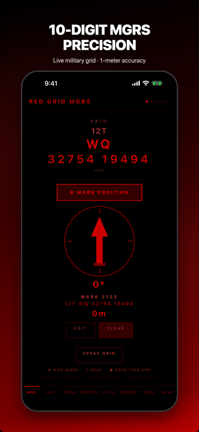
- ✓ Live MGRS coordinates (4/6/8/10-digit)
- ✓ Waypoint storage with bearing/distance
- ✓ Magnetic declination (WMM)
- ✓ Multiple coordinate formats
- ✓ Full offline operation
What Red Grid MGRS Adds
- + 10 tactical tools
- + 6 radio-ready report templates
- + Offline tactical maps with tile download
- + Meshtastic mesh networking
- + NATO voice readout
- + External GPS, GPX/KML, mission planning
What Red Grid MGRS Does
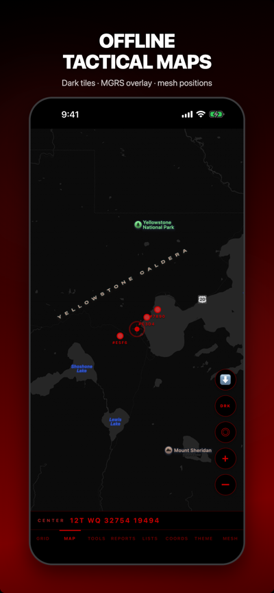
Offline Tactical Maps
Download tiles for your AO. Three map styles: standard, dark tactical, and topographic with contour lines. Toggle offline mode for zero-network map use.
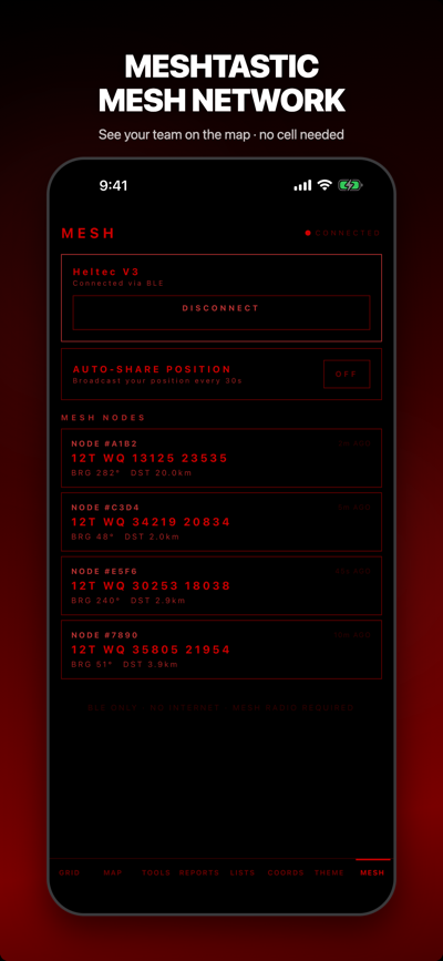
Off-Grid Mesh Positions
Pair a Meshtastic radio over BLE, see nearby node positions on your map, and optionally send your current grid over LoRa. No cell service, no internet needed.
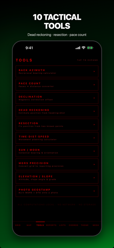
10 Tactical Tools
Back azimuth, dead reckoning, two-point resection, pace count, declination, TDS, sun/moon, precision selector, elevation/slope, photo geostamp.
6 Report Templates
SALUTE, 9-Line MEDEVAC, SPOT report, ICS 201 briefing, CASEVAC request, CFF fire mission. Pre-formatted for radio transmission.
NATO Voice Readout
Proper phonetic pronunciation of grid coordinates. Shake to speak. Hands-free grid calls with correct NATO digit pronunciation.
External GPS
Garmin GLO, Bad Elf, and other BLE GPS receivers for enhanced accuracy beyond your phone's built-in GPS.
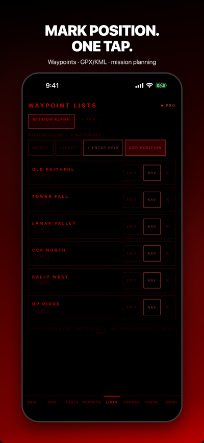
Mission Planning
Route overlay on map with leg distances and nearest-neighbor optimization. GPX/KML import via document picker, export via Share sheet.
Photo Geostamp
Burns MGRS coordinates and date-time-group onto photos. Tactical documentation without modifying camera roll originals.
4 Tactical Themes
Red Lens (night vision preservation), NVG Green (NOD compatible), Day White (high-contrast daylight), Blue Force (tactical blue). OLED true black.
Who It's For
Military & Law Enforcement
Land-nav training, patrol reporting, call for fire, MEDEVAC. Offline maps and Meshtastic mesh for zero-infrastructure environments.
SAR & First Responders
Backcountry search with military-grade precision. Waypoints, bearing/distance, dead reckoning, offline maps. No cell service needed.
Hunting & Backcountry
Mark stands, camps, and trailheads in MGRS. Topographic tiles with contour lines, slope and pace tools, and a grid you can read aloud over the radio.
Overlanding & Off-Road
Plot routes and waypoints, download tiles for the whole trail, and keep a precise grid fix when the trail leaves cell coverage.
Preparedness & Survival
A grid reference that needs no network, no account, and no tracking. Cache your area now; it works when the towers don't.
Students & Land-Nav
Practice 10-digit grids, resection, dead reckoning, and declination on real terrain — the same core math as a $2,500 DAGR, for free.
Pricing
- Full 10-digit MGRS at 1m precision
- Magnetic declination (WMM)
- Core tactical tools + 3 reports
- 1 saved waypoint (unlimited with Pro)
- No account, no tracking, ever
- 10-digit MGRS (1m precision)
- All 10 tools, all 6 reports
- Offline maps + Meshtastic mesh
- All 4 themes, unlimited waypoints
- Cancel anytime
- Start with a 7-day free trial
- All 10 tools, all 6 reports
- Offline maps + Meshtastic mesh
- All themes, unlimited waypoints
- Save 37% vs monthly
- Support development
- All 10 tools, all 6 reports
- Offline maps + Meshtastic mesh
- All themes, unlimited waypoints
- Pay once, own forever
- All future updates included
Recently Shipped & Coming Next
v3.4 — Mission Preflight ✓
Live on iOS and Google Play. New Mission Preflight panel on the Map tab gives a one-glance READY / CAUTION / NOT READY summary covering GPS source, Meshtastic radio, offline tile coverage, missing zooms, permissions, and battery hints. Saved AO Packages bundle map style + zoom set + tile count into a named area of operations — free tier gets 1 AO, Pro gets unlimited with one-tap refresh.
v3.3.5 — Reliability + Privacy Reset ✓
External GPS receivers (Garmin GLO, Bad Elf) now drive every screen, not just settings. Mesh auto-share actually broadcasts your active position over LoRa. New Pro route-planning workflow on the map — tap waypoints to build a route, see distance and est. time. First-launch attribution call removed to match the no-tracking policy.
v3.5 — Route Card + Field Export
Up next. Route card with ordered waypoints, leg distance, leg bearing, total distance, est. time, start DTG, notes. Export to GPX route/track, KML, KMZ, or plain-text card for radio, clipboard, or share sheet. Elevation profile from waypoint altitude + GPS altitude. Templates for patrol routes, SAR sweeps, rally / OBJ sets, and land-nav courses.
Frequently Asked Questions
Is Red Grid MGRS free?
Yes. The app is free to download with full 10-digit MGRS at 1-meter precision, magnetic declination, core tools, and radio-ready reports. Pro adds all 10 tactical tools, offline maps, Meshtastic mesh, every report and theme, and unlimited waypoints.
Does it work without an internet connection?
Yes. The app uses your phone's GPS receiver, which talks directly to satellites — no cell tower, no Wi-Fi, no internet required. Cache map tiles for your area and the map works fully offline.
What is MGRS, and how is it different from latitude/longitude?
MGRS (Military Grid Reference System) is built on UTM and adds a grid-zone designator plus 100 km square ID. It produces shorter, easier-to-read coordinates for radio voice reports and fast plotting. Red Grid MGRS shows MGRS plus decimal and DMS formats. Need to convert a coordinate right now? Try the free online MGRS converter.
Is this a replacement for the DAGR (AN/PSN-13)?
For training, STX lanes, ruck marches, and permissive GPS environments it covers the same core land-navigation capabilities — live MGRS, declination, waypoints, bearing, distance, dead reckoning. The DAGR's SAASM module matters in contested environments; for the other 90% of use, Red Grid runs the same core math on the phone in your pocket.
Does Red Grid MGRS collect or share my location?
No. Zero analytics, zero tracking, zero accounts, zero crash reporting. Your GPS coordinates exist in device memory only and never leave the phone. Verify it yourself: switch to airplane mode and the app keeps working — there is no network traffic to send anywhere.
Is Red Grid MGRS available on Android?
Yes. Red Grid MGRS is live on Google Play — same features, same zero-network architecture, same pricing. Android 7+ (API 24+), phones and tablets.
What does the Pro upgrade unlock?
All 10 tactical tools, offline maps, Meshtastic mesh, all 4 themes, unlimited waypoints, and all 6 radio-ready reports (SALUTE, MEDEVAC, SPOT, ICS-201, CASEVAC, ANGUS/CFF). Available at $3.99/month, $29.99/year, or $199.99 lifetime.
Built by an active-duty Army officer — read the story.
Moving as a team?
Red Grid MGRS is built for the solo operator. When you need to see your whole team on one map, Red Grid Link adds encrypted phone-to-phone position sharing, roles, and team coordination — same MGRS engine, no cell service or accounts.
Explore Red Grid LinkYour grid reference, always ready
Download Red Grid MGRS for offline-first grid navigation, Mission Preflight, Saved AO Packages, optional Meshtastic awareness, and 10 tactical tools.
Try Red Grid Pro free for 7 days on the annual plan — no charge today, cancel anytime.